WMS:Display Order: Difference between revisions
No edit summary |
No edit summary |
||
| (One intermediate revision by the same user not shown) | |||
| Line 1: | Line 1: | ||
The display order specifies the order that objects are displayed in WMS. The WMS default is to turn the display order on, which means objects are displayed in the order specified in the [[WMS:Display Options|WMS ''Display Options'']] dialog. When the display order is turned off, objects that have XYZ coordinates that are closer to the user's eye are displayed in front of objects that are further. Turning the display order off can often have undesirable consequences when displaying layers of watershed data in plan view. However, it can be useful to turn the display order on when displaying texture mapped TINs or shaded data in oblique view. See the adjacent images for examples of data displayed in plan and oblique view with display order turned off and on. | The display order specifies the order that objects are displayed in WMS. The WMS default is to turn the display order on, which means objects are displayed in the order specified in the [[WMS:Display Options|WMS ''Display Options'']] dialog. When the display order is turned off, objects that have XYZ coordinates that are closer to the user's eye are displayed in front of objects that are further. Turning the display order off can often have undesirable consequences when displaying layers of watershed data in plan view. However, it can be useful to turn the display order on when displaying texture mapped TINs or shaded data in oblique view. See the adjacent images for examples of data displayed in plan and oblique view with display order turned off and on. | ||
<gallery widths="350px" heights="250px"> | |||
Image:DisplayOrderOffPlanView.png|A plan view of a delineated watershed with display order turned '''off'''. Notice several contours and other objects "bleed" through the polygons to make things look cluttered. | |||
Image:DisplayOrderOnPlanView.png|A plan view of a delineated watershed with display order turned '''on'''. Notice the cleaner look of the watershed map. | |||
Image:DisplayOrderOnObliqueView.png|An oblique view of a delineated watershed with display order turned '''on'''. Notice how the contours look cluttered because entire objects are displayed using display order instead of closer entities being displayed in front of entities that are further away. | |||
Image:DisplayOrderOffObliqueView.png|An oblique view of a delineated watershed with display order turned '''off'''. Notice the cleaner look of the watershed map. | |||
</gallery> | |||
==Related Topics== | ==Related Topics== | ||
| Line 18: | Line 15: | ||
[[Category:WMS General Information|D]] | [[Category:WMS General Information|D]] | ||
[[Category:WMS Display Options|D]] | [[Category:WMS Display Options|D]] | ||
[[Category:Gallery]] | |||
Latest revision as of 15:24, 28 September 2017
The display order specifies the order that objects are displayed in WMS. The WMS default is to turn the display order on, which means objects are displayed in the order specified in the WMS Display Options dialog. When the display order is turned off, objects that have XYZ coordinates that are closer to the user's eye are displayed in front of objects that are further. Turning the display order off can often have undesirable consequences when displaying layers of watershed data in plan view. However, it can be useful to turn the display order on when displaying texture mapped TINs or shaded data in oblique view. See the adjacent images for examples of data displayed in plan and oblique view with display order turned off and on.
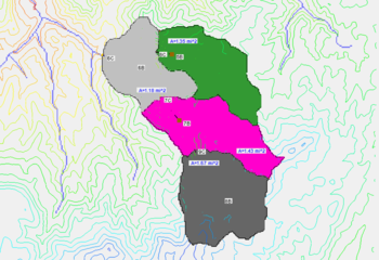
A plan view of a delineated watershed with display order turned off. Notice several contours and other objects "bleed" through the polygons to make things look cluttered.
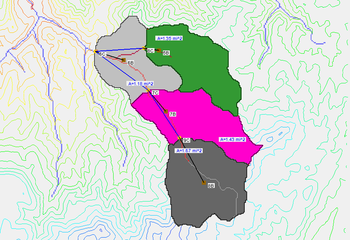
A plan view of a delineated watershed with display order turned on. Notice the cleaner look of the watershed map.
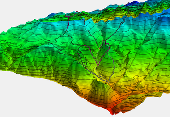
An oblique view of a delineated watershed with display order turned on. Notice how the contours look cluttered because entire objects are displayed using display order instead of closer entities being displayed in front of entities that are further away.
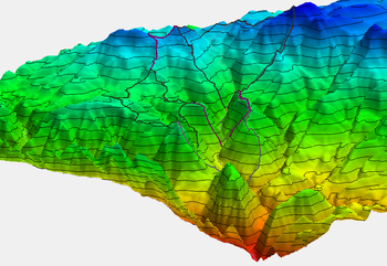
An oblique view of a delineated watershed with display order turned off. Notice the cleaner look of the watershed map.


Related Topics
WMS – Watershed Modeling System | ||
|---|---|---|
| Modules: | Terrain Data • Drainage • Map • Hydrologic Modeling • River • GIS • 2D Grid • 2D Scatter |  |
| Models: | CE-QUAL-W2 • GSSHA • HEC-1 • HEC-HMS • HEC-RAS • HSPF • MODRAT • NSS • OC Hydrograph • OC Rational • Rational • River Tools • Storm Drain • SMPDBK • SWMM • TR-20 • TR-55 | |
| Toolbars: | Modules • Macros • Units • Digitize • Static Tools • Dynamic Tools • Drawing • Get Data Tools | |
| Aquaveo | ||