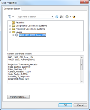
WMS:Map Properties
The Map Properties dialog is used when ArcObjects© is enabled to specify the coordinate system to display (or map features) from the ArcGIS© data layer. An ArcGIS data layer should have a currently defined coordinate system associated with it. If the coordinate system is geographic (latitude/longitude), then ArcObjects© is able to "guess" correctly at the projection. Using the coordinate system as defined in the Map Properties a user can specify the coordinate system to use to display features or rasters in WMS. While this does not change the actual geometry of the layer, it will display in the WMS window according to this projection and any data mapped to WMS coverages will be mapped into the coordinate system specified by the Map Properties dialog.
Map Properties Dialog
The dialog is accessed through the Data | Map Properties command when ArcObjects© is active. The dialog has the following options:
- Spacial Filter

- Search
- Clear Search
- Add Coordinate System
- Add to Favorites
- Coordinate systems browser
- Current coordinate system
- Transformations
Related Topics
WMS – Watershed Modeling System | ||
|---|---|---|
| Modules: | Terrain Data • Drainage • Map • Hydrologic Modeling • River • GIS • 2D Grid • 2D Scatter |  |
| Models: | CE-QUAL-W2 • GSSHA • HEC-1 • HEC-HMS • HEC-RAS • HSPF • MODRAT • NSS • OC Hydrograph • OC Rational • Rational • River Tools • Storm Drain • SMPDBK • SWMM • TR-20 • TR-55 | |
| Toolbars: | Modules • Macros • Units • Digitize • Static Tools • Dynamic Tools • Drawing • Get Data Tools | |
| Aquaveo | ||
