|
|
| (13 intermediate revisions by 2 users not shown) |
| Line 1: |
Line 1: |
| {{GIS links}} | | {{GIS links}} |
| [[Image:image95.jpg|right|frame|]]
| |
| GIS vector data can be converted to Feature Objects (points, arcs, polygons in coverages) for use in a conceptual model. Attributes associated with the GIS data can also be mapped over to attributes associated with Feature Objects. Two commands are available for converting GIS vector data to Feature Objects: '''''GIS | ArcObjects → Feature Objects''''' and '''''GIS | Shapes → Feature Objects'''''.
| |
|
| |
|
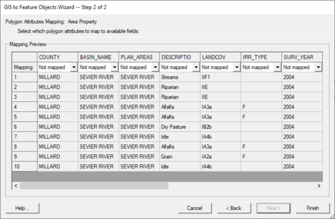
| Selecting the '''''GIS | ArcObjects → Feature Objects''''' command (with an ArcObjects license), or the '''''GIS | Shapes → Feature Objects''''' (without an ArcObjects license) launches a mapping wizard which guides you through the process of converting your GIS data layer features to feature objects in a map coverage. Before beginning the mapping process you should first go to the map module and make sure that the currently active coverage is the coverage you wish to map GIS data layer features to. Also, you will associate the GIS attributes with GMS coverage attributes, so you must make sure the GMS coverage attributes are defined before you can do the conversion.
| | GIS vector data can be converted to [[GMS:Feature Objects|feature objects]] (points, arcs, polygons in coverages) for use in a [[GMS:Conceptual Model|conceptual model]]. Attributes associated with the GIS data can also be mapped over to attributes associated with Feature Objects. Two commands are available for converting GIS vector data to feature objects: ''GIS'' | '''ArcObjects → Feature Objects''' (with an ArcObjects license) and ''GIS'' | '''Shapes → Feature Objects'''. Selecting either of these commands will bring up ''GIS to Feature Objects'' wizard. |
|
| |
|
| After making sure you will be mapping to the correct coverage select the GIS features which overlay your study area and that you wish to map (this is done with the selection tool(s) in the GIS module). If you wish to map all the features you can choose the '''''Edit | Select All''''' command, or just execute the Mapping command, and you will be prompted if you want to convert all features since none are selected.
| | Before starting the wizard, make sure to set the appropriate coverage as the active coverage since the wizard will convert the GIS data to new Feature Objects in the active coverage. Also, if mapping over attributes, make sure the GMS coverage attributes are defined before doing the conversion. |
|
| |
|
| If you have ArcObjects enabled you will see that the '''''GIS | ArcObjects → Feature Objects''''' command is activated whereas if you do not have ArcObjects enabled you will see that the '''''GIS | Shapes → Feature Objects''''' command is activated. After choosing the appropriate mapping command you will see the Mapping Wizard shown below. This wizard will guide you through the rest of the process. The first dialog in the mapping wizard contains instructions and marks the beginning point of mapping for selected features. The first of two steps is to map the attribute fields of the features to attributes used by GMS. GMS recognizes some attribute names as commonly used for certain attributes and maps them automatically. | | If the user only wishes to convert a portion of the GIS vector data to feature objects then select the desired GIS data before beginning the wizard. If the user wishes to map all the features, begin the wizard and it will ask if the user wants to convert all features since none are selected. |
|
| |
|
| The second step marks the end of the wizard and after selecting Finish all selected features will be converted to feature objects within the active coverage. Attributes of mapped fields will be saved accordingly as attributes of the feature objects.
| | Follow the instructions in the mapping wizard to convert the GIS data to feature objects. |
| | |
| | [[File:GIS to Feature Objects Wizard -- Step 1 of 2.jpg|thumb|none|left|475 px|''GIS to Feature Objects Wizard'' dialog showing the first step in the conversion process.]] |
|
| |
|
| {{Navbox GMS}} | | {{Navbox GMS}} |
| [[Category:GIS]] | | [[Category:GIS]] |
| | [[Category:GMS Dialogs|G]] |
GIS vector data can be converted to feature objects (points, arcs, polygons in coverages) for use in a conceptual model. Attributes associated with the GIS data can also be mapped over to attributes associated with Feature Objects. Two commands are available for converting GIS vector data to feature objects: GIS | ArcObjects → Feature Objects (with an ArcObjects license) and GIS | Shapes → Feature Objects. Selecting either of these commands will bring up GIS to Feature Objects wizard.
Before starting the wizard, make sure to set the appropriate coverage as the active coverage since the wizard will convert the GIS data to new Feature Objects in the active coverage. Also, if mapping over attributes, make sure the GMS coverage attributes are defined before doing the conversion.
If the user only wishes to convert a portion of the GIS vector data to feature objects then select the desired GIS data before beginning the wizard. If the user wishes to map all the features, begin the wizard and it will ask if the user wants to convert all features since none are selected.
Follow the instructions in the mapping wizard to convert the GIS data to feature objects.
GIS to Feature Objects Wizard dialog showing the first step in the conversion process.
