WMS:Land Use: Difference between revisions
No edit summary |
No edit summary |
||
| Line 3: | Line 3: | ||
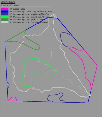
With a land use grid, WMS uses the ID associated with each cell in the land use grid to determine the land use value. When there is a land use coverage defined, WMS uses the ID associated with each polygon to determine the land use. The land use table attributes can be edited by right-clicking on the land use grid or by going to the attributes of a selected land use polygon in the land use coverage. When there is both a land use grid and a land use coverage, it can be selected whether there is a land use grid or a land use coverage in the drop down box. | With a land use grid, WMS uses the ID associated with each cell in the land use grid to determine the land use value. When there is a land use coverage defined, WMS uses the ID associated with each polygon to determine the land use. The land use table attributes can be edited by right-clicking on the land use grid or by going to the attributes of a selected land use polygon in the land use coverage. When there is both a land use grid and a land use coverage, it can be selected whether there is a land use grid or a land use coverage in the drop down box. | ||
[[Image:luse.jpg]] | |||
==Related Topics== | ==Related Topics== | ||
Latest revision as of 16:56, 1 July 2019
In the Compute GIS Attributes dialog, the Land Use option determines whether a land use coverage or a land use grid will be used. The critical attribute for land use is an ID that can be related to a table of parameters for curve numbers, Green & Ampt parameters, HSPF segments, or any other hydrologic parameter that requires a land use ID for computation.
With a land use grid, WMS uses the ID associated with each cell in the land use grid to determine the land use value. When there is a land use coverage defined, WMS uses the ID associated with each polygon to determine the land use. The land use table attributes can be edited by right-clicking on the land use grid or by going to the attributes of a selected land use polygon in the land use coverage. When there is both a land use grid and a land use coverage, it can be selected whether there is a land use grid or a land use coverage in the drop down box.
Related Topics
- Compute GIS Attributes
- Soil Type
- Mapping Tables
- Land Use Coverage
- Obtaining Land Use Data from the Internet
WMS – Watershed Modeling System | ||
|---|---|---|
| Modules: | Terrain Data • Drainage • Map • Hydrologic Modeling • River • GIS • 2D Grid • 2D Scatter |  |
| Models: | CE-QUAL-W2 • GSSHA • HEC-1 • HEC-HMS • HEC-RAS • HSPF • MODRAT • NSS • OC Hydrograph • OC Rational • Rational • River Tools • Storm Drain • SMPDBK • SWMM • TR-20 • TR-55 | |
| Toolbars: | Modules • Macros • Units • Digitize • Static Tools • Dynamic Tools • Drawing • Get Data Tools | |
| Aquaveo | ||
