GMS:Add Data: Difference between revisions
From XMS Wiki
Jump to navigationJump to search
No edit summary |
|||
| (3 intermediate revisions by the same user not shown) | |||
| Line 7: | Line 7: | ||
==Add Data== | ==Add Data== | ||
The ''Data'' | '''Add Data''' command is available when ArcObjects® is enabled and uses the same dialog resource to open GIS data layers that is used by ArcView®. | {{GMS Deprecated Feature}} | ||
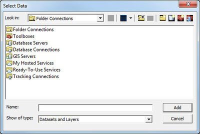
The ''Data'' | '''Add Data''' command is available when [[ArcObjects|ArcObjects®]] is enabled and uses the same dialog resource to open GIS data layers that is used by ArcView®. | |||
[[File:Add Data Dialog.jpg|thumb|none|left|400 px|''Select Data'' dialog]] | [[File:Add Data Dialog.jpg|thumb|none|left|400 px|''Select Data'' dialog]] | ||
When | When ArcObjects® is enabled, GMS is able to load any of the ESRI supported formats, including shapefiles, coverages, geodatabases, grids, images, CAD files and others, as GIS data layers. These data can then be converted to GMS feature objects in map coverages. See ArcGIS documentation for details on how to use this dialog. | ||
{{Navbox GMS}} | {{Navbox GMS}} | ||
[[Category:GIS]] | [[Category:GIS]] | ||
[[Category:GMS GIS Dialogs]] | [[Category:GMS GIS Dialogs]] | ||
