GMS:FEMWATER Commands
The FEMWATER menu becomes available after a FEMWATER simulation has been created. Below the commands in this menu:
- New Simulation...
Starts a new FEMWATER simulation. This command will delete any existing FEMWATER data running in GMS.
- Delete Simulation...
Removes the selected FEMWATER simulation.
- Check Simulation...
Starts the Model Checker dialog.
- Run FEMWATER...
Executes the FEMWATER model.
- Read Solution...
Opens a FEWATER solution file.
- Geometry File...
Opens the Geomtery File dialog where preferences for saving geometry files can be set.
- Titles...
Brings up the FEMWATER Geometry and Model Title Cards dialog. See Titles for more information.
- Run Options...
Opens the FEMWATER Run Options dialog.
- Initial Conditions...
Opens the FEMWATER Initial Conditions dialog. See FEMWATER Initial Conditions for more information.
- Iteration Parameters...
Brings up the Iteration Parameters dialog. See Iteration Parameters for more information.
- Particle Tracking...
Opens the FEMWATER Particle Tracking dialog. See Particle Tracking Parameters for more information.
- Time Control...
Opens the FEMWATER Time Control dialog. See Time Control Parameters for more information.
- Output Control...
Brings up the FEMWATER Output Control dialog. See Output Control for more information.
- Fluid Properties...
Opens the FEMWATER Fluid Properties dialog. See Fluid Properties for more information.
- BC Display Options...
Brings up the Display Options dialog showing the FEMWATER tab.
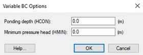
- Variable BC Options...
Opens the Variable BC Options dialog.
- Assign Node/Face BC...
Either assigns a new boundary condition or edits an existing boundary condition to a selected set of boundary nodes or boundary element faces. See Assign Node/Face BC for more information.
- Point Source/Sink BC...
Assigns a flow rate to a node. See Point Source/Sink BC (Wells) for more information.
- Delete BC
Removes selected boundary condition.
Related Topics
GMS – Groundwater Modeling System | ||
|---|---|---|
| Modules: | 2D Grid • 2D Mesh • 2D Scatter Point • 3D Grid • 3D Mesh • 3D Scatter Point • Boreholes • GIS • Map • Solid • TINs • UGrids | |
| Models: | FEFLOW • FEMWATER • HydroGeoSphere • MODAEM • MODFLOW • MODPATH • mod-PATH3DU • MT3DMS • MT3D-USGS • PEST • PHT3D • RT3D • SEAM3D • SEAWAT • SEEP2D • T-PROGS • ZONEBUDGET | |
| Aquaveo | ||
