WMS:GSSHA: Difference between revisions
| (48 intermediate revisions by 4 users not shown) | |||
| Line 1: | Line 1: | ||
GSSHA is a two-dimensional finite difference rainfall/runoff model. A finite difference grid is used to establish the computational domain and parameters for surface runoff. The GSSHA model is fully coupled with hydraulic stream flow/routing models. Parameters for stream channels are defined using arcs and then mapped to the appropriate underlying grid cells. | {{TOC right}} | ||
Gridded Surface Subsurface Hydrologic Analysis (GSSHA) is a two-dimensional finite difference rainfall/runoff model. A finite difference grid is used to establish the computational domain and parameters for surface runoff. The GSSHA model is fully coupled with hydraulic stream flow/routing models. Parameters for stream channels are defined using arcs and then mapped to the appropriate underlying grid cells. | |||
Features of GSSHA include 1D stream flow and infiltration, 2D overland flow and groundwater, and full coupling between the groundwater, shallow soils, streams, and overland flow.<ref name="GSSHA overview">{{cite web|url=http://www.gsshawiki.com/Overview:Overview|title=Overview:Overview|publisher=GSSHA Wiki|accessdate=April 26, 2019}}</ref> "Sediment and constituent fate and transport are simulated in the shallow soils, overland flow plane, and in streams and channels. GSSHA can be used as an episodic or continuous model where soil surface moisture, groundwater levels, stream interactions, and constituent fate are continuously simulated. The fully coupled groundwater to surface-water interaction allows GSSHA to model basins in both arid and humid environments."<ref name="GSSHA overview"/> | |||
The GSSHA model can be added to a | The GSSHA model can be added to a paid edition of WMS.<ref name="WMS Pricing">{{cite web|url=http://www.aquaveo.com/software/wms-pricing|title=WMS Editions & Pricing|publisher=Aquaveo|accessdate=April 26, 2019}}</ref> | ||
== | ==GSSHA Menus== | ||
There are two ''GSSHA'' menus in WMS: | |||
*When in the '''Map Module''' [[File:Map Module Icon.svg|16px]], the ''GSSHA'' menu is available when a GSSHA coverage is selected. See [[WMS:GSSHA Menu#GSSHA Coverage Menu|here]] for more details. | |||
*When in the '''2-D Grid Module''' [[File:2D Grid Icon.svg|16px]], the main ''GSSHA'' menu is available. See [[WMS:GSSHA Menu#GSSHA Grid Menu|here]] for more details. | |||
== | ==Cell Properties== | ||
The 2D grid cell properties include an ''I,J'' location and a scalar or index map value. The scalar or index map value is associated with the currently selected dataset in the Project Explorer and can be edited in the Properties Window. The ''I,J'' location can be viewed but not edited in the Properties Window. The 2D grid contours are a way of visualizing the spatial variation of the scalar or index map values for the selected dataset. | |||
The | |||
The | |||
==GSSHA Model Check== | |||
{{anchor|Model Check}}[[File:Dialog GSSHA Model Check.png|thumb|right|380px|''GSSHA Model Check'' dialog]] | |||
The ''GSSHA Model Check'' dialog lists potential problems with the GSSHA model. It is accessed by selecting ''GSSHA'' | '''Model Check...''' while in the '''2-D Grid Module''' [[File:2D Grid Icon.svg|14px]]. The model check runs through the input data for a GSSHA simulation and looks for obvious inconsistencies and problems with the model. The model check will find logical problems, but will not identify values that are outside of plausible ranges. | |||
An example of a problem that the model checker would not find is if a stream arc has a pit that pools water. Examples of potential problems that will be identified by the model check: | |||
*An index map has one or more cells whose ID is "0" (which is not allowed in GSSHA). | |||
*A specified process that has an ID with parameters whose values are "0.00" (which indicates an incomplete entry). | |||
Clicking on a specific warning or error will open a dialog that will allow the potential problem to be fixed, if needed. | |||
At the bottom of the dialog are three buttons: | |||
*'''Help''' – Opens this article in a web browser. | |||
*'''Done''' – Closes the ''GSSHA Model Check'' dialog. | |||
*'''Print''' – Opens a ''Choose name of output file'' dialog. Enter the desired ''File name'' and click '''Save''' to export the model check information to a text file. | |||
== | ==GSSHA Run Options== | ||
{{anchor|Run Options}} | |||
[[File:Dialog GSSHA Run Options.png|thumb|right|280 px|''GSSHA Run Options'' dialog]] | |||
The ''GSSHA Run Options'' dialog lists options for running the GSSHA model. It is accessed by selecting ''GSSHA'' | '''Run GSSHA...''' while in the '''2-D Grid Module''' [[File:2D Grid Icon.svg|14px]]. | |||
The following sections and options are found in this dialog: | |||
*''Location'' section – Lists the GSSHA project file that will be run. Click [[File:Open Macro.svg|16px]] to open a ''Save GSSHA Project File'' dialog. Select the desired project, or enter a new ''File name'' and click '''Save''' to close the ''Save GSSHA Project File'' dialog. | |||
*''Options'' section – The following options can be turned on or off: | |||
**''Suppress screen printing'' – Suppresses the output of runtime data from GSSHA at each time step, significantly reducing the overall run time required for a GSSHA simulation. This option requires that the ''Save file before running'' be turned on. | |||
**''Save file before running'' – Instructs GSSHA to save the project file prior to running GSSHA. | |||
**''Pause GSSHA window after running'' | |||
At the bottom of the dialog are the following buttons: | |||
*'''OK''' – Saves the changes and opens the [[WMS:Model Wrapper|Model Wrapper]]. | |||
*'''Cancel''' – Cancels the GSSHA model run and closes the ''GSSHA Run Options'' dialog. | |||
* [[WMS: | |||
* | |||
==Read GSSHA Solution== | |||
{{anchor|Read Solution}}[[File:WMS Read GSSHA Solution dialog.png|thumb|right|280 px|''Read GSSHA Solution'' dialog]] | |||
The ''Read GSSHA Solution'' dialog allows previously saved GSSHA solutions to be imported into a GSSHA project. The dialog contains the following information: | |||
*''Simulation'' – The selected GSSHA project file name containing solution data. | |||
*''Path'' – The file path to the selected GSSHA project file. | |||
*'''Select Simulation...''' – Brings up an ''Open'' dialog, allowing browsing to and selection of the desired GSSHA project file. | |||
*''Solution file''' – Indicates whether the selected GSSHA project file contains solution data. | |||
At the bottom of the dialog are the following buttons: | |||
*'''Help''' – Opens this article in a web browser. | |||
*'''OK''' – Saves and changes, closes the ''Read GSSHA Solution'' dialog, and imports the solution data. The solution data will be within a [[File:Generic Folder Locked.svg|14px]] GSSHA solutions folder. | |||
*'''Cancel''' – Discards and changes and closes the ''Read GSSHA Solution'' dialog. | |||
{{ | ==References== | ||
{{reflist}} | |||
}} | {{GSSHA Wiki}} | ||
{{WMSMain}} | |||
[[Category:GSSHA|G]] | [[Category:GSSHA|G]] | ||
[[Category:GSSHA Dialogs]] | [[Category:GSSHA Dialogs|G]] | ||
[[Category:External Links]] | [[Category:External Links]] | ||
[[Category:Link to Store]] | |||
Latest revision as of 23:05, 13 May 2021
Gridded Surface Subsurface Hydrologic Analysis (GSSHA) is a two-dimensional finite difference rainfall/runoff model. A finite difference grid is used to establish the computational domain and parameters for surface runoff. The GSSHA model is fully coupled with hydraulic stream flow/routing models. Parameters for stream channels are defined using arcs and then mapped to the appropriate underlying grid cells.
Features of GSSHA include 1D stream flow and infiltration, 2D overland flow and groundwater, and full coupling between the groundwater, shallow soils, streams, and overland flow.[1] "Sediment and constituent fate and transport are simulated in the shallow soils, overland flow plane, and in streams and channels. GSSHA can be used as an episodic or continuous model where soil surface moisture, groundwater levels, stream interactions, and constituent fate are continuously simulated. The fully coupled groundwater to surface-water interaction allows GSSHA to model basins in both arid and humid environments."[1]
The GSSHA model can be added to a paid edition of WMS.[2]
GSSHA Menus
There are two GSSHA menus in WMS:
- When in the Map Module
 , the GSSHA menu is available when a GSSHA coverage is selected. See here for more details.
 - When in the 2-D Grid Module
 , the main GSSHA menu is available. See here for more details.
Cell Properties
The 2D grid cell properties include an I,J location and a scalar or index map value. The scalar or index map value is associated with the currently selected dataset in the Project Explorer and can be edited in the Properties Window. The I,J location can be viewed but not edited in the Properties Window. The 2D grid contours are a way of visualizing the spatial variation of the scalar or index map values for the selected dataset.
GSSHA Model Check
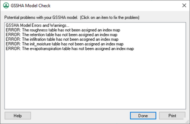
The GSSHA Model Check dialog lists potential problems with the GSSHA model. It is accessed by selecting GSSHA | Model Check... while in the 2-D Grid Module ![]() . The model check runs through the input data for a GSSHA simulation and looks for obvious inconsistencies and problems with the model. The model check will find logical problems, but will not identify values that are outside of plausible ranges.
. The model check runs through the input data for a GSSHA simulation and looks for obvious inconsistencies and problems with the model. The model check will find logical problems, but will not identify values that are outside of plausible ranges.
An example of a problem that the model checker would not find is if a stream arc has a pit that pools water. Examples of potential problems that will be identified by the model check:
- An index map has one or more cells whose ID is "0" (which is not allowed in GSSHA).
- A specified process that has an ID with parameters whose values are "0.00" (which indicates an incomplete entry).
Clicking on a specific warning or error will open a dialog that will allow the potential problem to be fixed, if needed.
At the bottom of the dialog are three buttons:
- Help – Opens this article in a web browser.
- Done – Closes the GSSHA Model Check dialog.
- Print – Opens a Choose name of output file dialog. Enter the desired File name and click Save to export the model check information to a text file.
GSSHA Run Options
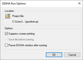
The GSSHA Run Options dialog lists options for running the GSSHA model. It is accessed by selecting GSSHA | Run GSSHA... while in the 2-D Grid Module ![]() .
.
The following sections and options are found in this dialog:
- Location section – Lists the GSSHA project file that will be run. Click
 to open a Save GSSHA Project File dialog. Select the desired project, or enter a new File name and click Save to close the Save GSSHA Project File dialog.
 - Options section – The following options can be turned on or off:
- Suppress screen printing – Suppresses the output of runtime data from GSSHA at each time step, significantly reducing the overall run time required for a GSSHA simulation. This option requires that the Save file before running be turned on.
- Save file before running – Instructs GSSHA to save the project file prior to running GSSHA.
- Pause GSSHA window after running
At the bottom of the dialog are the following buttons:
- OK – Saves the changes and opens the Model Wrapper.
- Cancel – Cancels the GSSHA model run and closes the GSSHA Run Options dialog.
Read GSSHA Solution
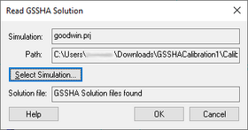
The Read GSSHA Solution dialog allows previously saved GSSHA solutions to be imported into a GSSHA project. The dialog contains the following information:
- Simulation – The selected GSSHA project file name containing solution data.
- Path – The file path to the selected GSSHA project file.
- Select Simulation... – Brings up an Open dialog, allowing browsing to and selection of the desired GSSHA project file.
- Solution file' – Indicates whether the selected GSSHA project file contains solution data.
At the bottom of the dialog are the following buttons:
- Help – Opens this article in a web browser.
- OK – Saves and changes, closes the Read GSSHA Solution dialog, and imports the solution data. The solution data will be within a
 GSSHA solutions folder.
 - Cancel – Discards and changes and closes the Read GSSHA Solution dialog.
References
- ^ a b "Overview:Overview". GSSHA Wiki. http://www.gsshawiki.com/Overview:Overview. Retrieved on April 26, 2019.
- ^ "WMS Editions & Pricing". Aquaveo. http://www.aquaveo.com/software/wms-pricing. Retrieved on April 26, 2019.
GSSHA | |
|---|---|
| XMS Wiki Links | Calibration (Automated • Manual • Output) • Channel Routing • Contaminants • Digital Dams • Embankment Arcs • Feature Objects (Arcs • Nodes • Polygons) • File Types • Groundwater • Groups • Hydraulic Structures • Job Control • Join SSURGO Data • Mapping Tables • Maps • Menu • Model Linkage • Multiple Simulations • Nutrients • Observations • Output Control • Overland Soil Erosion • Pipe and Node Parameters • Precipitation • Radar Rainfall • Save GSSHA Project File • Smooth GSSHA Streams • Snowmelt • Solution (Analysis • Data) |
| Related Tools | MWBM Wizard • Using Soil Type Data with GSSHA |
| GSSHA Wiki External Links | GSSHA Wiki: Overview • Primer • User's Manual • Tutorials |
WMS – Watershed Modeling System | ||
|---|---|---|
| Modules: | Terrain Data • Drainage • Map • Hydrologic Modeling • River • GIS • 2D Grid • 2D Scatter |  |
| Models: | CE-QUAL-W2 • GSSHA • HEC-1 • HEC-HMS • HEC-RAS • HSPF • MODRAT • NSS • OC Hydrograph • OC Rational • Rational • River Tools • Storm Drain • SMPDBK • SWMM • TR-20 • TR-55 | |
| Toolbars: | Modules • Macros • Units • Digitize • Static Tools • Dynamic Tools • Drawing • Get Data Tools | |
| Aquaveo | ||


